
DigitalGlobe, a Maxar Technologies company (NYSE:MAXR), in Westminster, Colorado, has harnessed artificial intelligence (AI), machine learning, and crowdsourcing technologies to map the entire continent of Australia at a unprecedented level of detail, officials say. PSMA Australia, an organization offering geospatial data to public and private institutions across the continent, selected DigitalGlobe to produce data layers to develop Geoscape, a commercial location intelligence dataset about the Australian-built environment designed to enable end users to make business decisions.
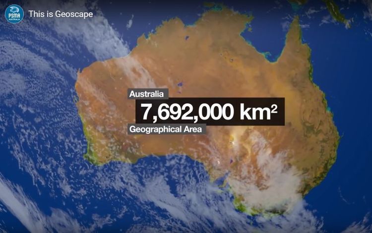
Geoscape accurately describes the physical attributes of every building across all 7.6 million square kilometers of Australia, to help transform workflows for monitoring, growth, and optimization across a broad spectrum of industries. Government and business customers can access the comprehensive, geospatial dataset without the need to gather data manually, hire GIS experts, or perform costly rounds of site visits.
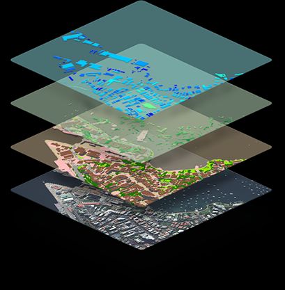
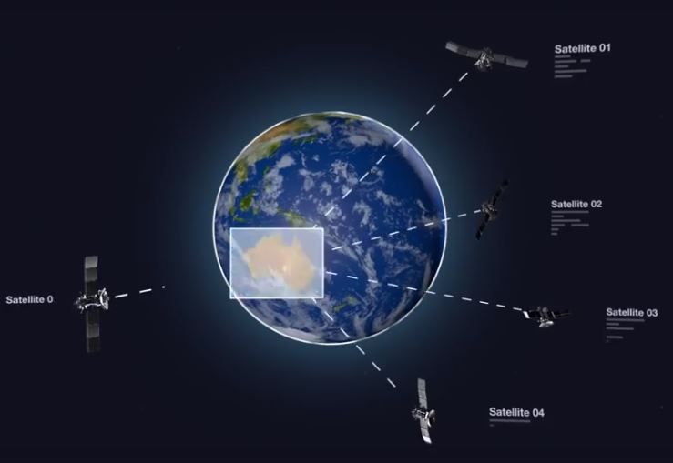
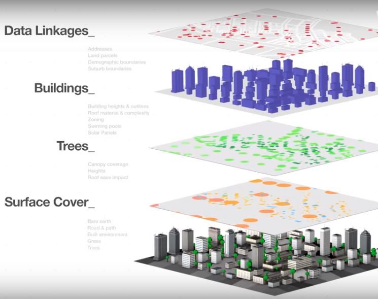
DigitalGlobe supplied the satellite imagery, analytics, and content ecosystem partners that enabled PSMA Australia to produce the dataset. DigitalGlobe tasked its WorldView-3 satellite to collect new imagery of the entire continent with its shortwave infrared (SWIR) sensor, enabling DigitalGlobe to identify materials on each property. DigitalGlobe leveraged its GBDX advanced cloud computing-based analytics platform, as well as its own algorithms and those from its content ecosystem partners to extract 105 different attributes about properties from the imagery, such as the precise location and height of trees and buildings, existence of swimming pools, land use, roof complexity, and distribution of solar panels.
Radiant Solutions, another Maxar company, produced a continent-scale Land Cover map created using artificial intelligence and a team of trained image analysts.
“This opportunity demonstrates the value of information available inside DigitalGlobe’s high-resolution satellite imagery that can be unlocked using advanced analytics, cloud computing, artificial intelligence, and big data processing,” says Dr. Shay Har-Noy, DigitalGlobe’s vice president of unified platforms. “DigitalGlobe collaborated with PSMA Australia to create Geoscape, and this detailed dataset is transforming businesses with actionable insight to enable faster and better decision-making.”
When data layers are combined to custom-fit the end user’s needs, they provide key insights for accomplishing projects faster, such as infrastructure planning for next-generation 5G networks, insurance risk modeling, and improved urban planning and taxation activities.
The completed Geoscape dataset reveals previously unknown statistics about Australia’s built environment including:
- 15,243,669 buildings
- 1,279,438 buildings with swimming pools
- 1,251,083 buildings with solar panels
“PSMA Australia is proud to be the first organization to offer a single, national dataset describing buildings and their features, trees and land cover for every address in Australia,” PSMA Australia’s Chief Executive Officer Dan Paull says . “This innovative dataset is only possible thanks to DigitalGlobe’s satellite imagery, analytics, and content ecosystem partners.”
PSMA will continue to update Geoscape over the next two years with fresh data layers from DigitalGlobe.
DigitalGlobe provides commercial high-resolution satellite imagery used by decision makers to better understand our changing planet in order to save lives, resources and time. Sourced from the world’s leading constellation, our imagery solutions deliver unmatched coverage and capacity to meet our customers’ most demanding mission requirements. Each day customers in defense and intelligence, public safety, civil agencies, map making and analysis, environmental monitoring, oil and gas exploration, infrastructure management, navigation technology, and providers of location-based services depend on DigitalGlobe data, information, technology and expertise to gain actionable insight. DigitalGlobe is a Maxar Technologies company (NYSE: MAXR) (TSX: MAXR).
A provider of advanced space technology solutions, Maxar Technologies is at the nexus of the new space economy, developing, and sustaining the infrastructure and delivering the information, services, systems that unlock the promise of space for commercial and government markets. Maxar Technologies provides vertically integrated capabilities and expertise including satellites, Earth imagery, robotics, geospatial data, and analytics to help customers anticipate and address their most complex mission-critical challenges with confidence. With more than 6,500 employees in over 30 global locations, the Maxar Technologies portfolio of commercial space brands includes MDA, SSL, DigitalGlobe, and Radiant Solutions.